







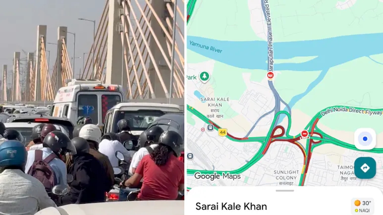


New Delhi: The Barapullah Phase 3 flyover was inaugurated with the promise of making travel between East and South Delhi faster, but the new elevated corridor quickly became a source of frustration for commuters after severe traffic congestion was reported soon after it opened.
The extension of the Barapullah network was designed to provide a signal-free connection between Mayur Vihar and Sarai Kale Khan, with onward connectivity towards South Delhi and AIIMS. The project was expected to reduce travel time significantly and ease pressure on some of the city’s busiest roads.
Instead, commuters encountered long queues around the Sarai Kale Khan end of the corridor, raising questions about whether increasing road capacity at one point in a network can simply shift congestion to another.
The situation has also prompted discussions about lane merging, traffic flows, navigation systems and the wider challenges of building elevated roads in densely populated cities.
What was Barapullah Phase 3 supposed to solve?
Barapullah Phase 3 was developed to improve connectivity between eastern and southern parts of Delhi and provide a faster route for commuters travelling between Mayur Vihar and areas around South Delhi.
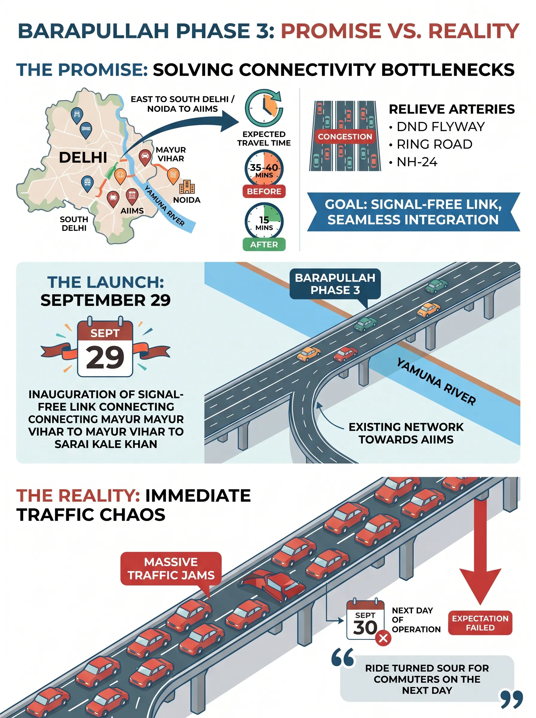
The signal-free corridor connects Mayur Vihar with Sarai Kale Khan across the Yamuna and links into the existing Barapullah network. The project was expected to reduce the journey between Mayur Vihar and South Delhi from around 35-40 minutes to roughly 15 minutes under suitable traffic conditions.
The wider objective was to reduce pressure on important traffic routes, including the DND Flyway, Ring Road and NH-24.
By creating an elevated alternative, the authorities hoped that traffic currently using congested surface roads would be redistributed across the network.
However, the experience after the corridor opened highlighted a key problem: a road can have sufficient capacity along most of its length and still become ineffective if traffic is forced through a much narrower section at the end.
Why are vehicles getting stuck at Sarai Kale Khan?
One of the main problems reported around the new corridor is the convergence of several traffic streams.
The Delhi Traffic Police responded to complaints on X and said that around eight to nine lanes of traffic were converging into three lanes.
This creates a significant capacity mismatch.
Vehicles can move relatively quickly while travelling along a wide elevated corridor, but when several streams suddenly have to merge into a smaller section, the flow can slow dramatically.
At Sarai Kale Khan, traffic from the new corridor interacts with vehicles already approaching the area from other routes, including traffic associated with the DND Flyway and existing road loops.
The resulting merging movement can create queues that stretch backwards into the flyover itself.
This is commonly described as a funnel effect. When a large volume of traffic enters a section with lower capacity, the narrower point determines how many vehicles can ultimately pass through.
In other words, adding capacity upstream does not necessarily increase the capacity of the entire journey.
How can a wider road create a new bottleneck?
The Barapullah situation illustrates a basic principle of road networks: the capacity of a route is often determined by its weakest or narrowest point.
Imagine a road that can carry thousands of vehicles per hour but eventually feeds into a much smaller junction. Increasing the capacity of the approach allows vehicles to reach that junction more quickly, but the junction itself still cannot process them at the same rate.
The result can be a queue at the point where the two capacities meet.
This is one reason transport planners generally examine an entire corridor rather than treating an individual flyover as an isolated piece of infrastructure.
The problem can become even more complicated when several roads, loops and ramps converge at the same location.
At Sarai Kale Khan, ongoing infrastructure work by the National Highways Authority of India (NHAI), including plans involving the Delhi-Mumbai Expressway and the Outer Ring Road, is another factor being considered in the wider traffic picture.
Is this an example of induced demand?
The congestion has also revived a familiar debate about induced demand.
Induced demand refers to a situation in which increasing road capacity encourages additional traffic. When a congested road becomes faster or more convenient, some people who previously avoided the route may start using it.
Others may change their travel time, route or mode of transport.
Over time, the additional traffic can consume much of the newly created capacity.
However, induced demand should not be confused with the immediate bottleneck being reported at Barapullah Phase 3.
The initial congestion around the new corridor can be explained more directly by the interaction between traffic volumes and the limited capacity at downstream junctions. Whether the new flyover ultimately generates substantial additional demand would require longer-term traffic data.
What is the Braess paradox?
Another concept being discussed in relation to road networks is the Braess paradox.
The paradox describes situations in which adding a new road or increasing capacity can, under certain network conditions, make overall traffic flow worse because drivers change their routes and the resulting traffic distribution creates additional congestion.
The key lesson is that a road network cannot always be improved simply by adding more road space.
A new connection changes how motorists choose their routes. If a large number of vehicles make the same change, the traffic pattern across the network can become less efficient.
That does not necessarily mean every new flyover will create congestion. The outcome depends on traffic demand, road design, junction capacity, signal timings, route choices and how different parts of the network interact.
What role is Google Maps playing?
The traffic problems also triggered a response from the Delhi Traffic Police regarding navigation apps.
According to the traffic police, Google Maps was not accurately reflecting the prevailing traffic conditions on the new Barapullah corridor.
The police said this could have encouraged more vehicles to use the route, contributing to heavy traffic volumes and a bottleneck at the Barapullah Junction.
The resulting congestion then extended for a considerable distance.
Navigation applications rely on a combination of mapping data, historical patterns and live traffic information. When a newly opened road is not yet represented accurately in traffic-routing systems, motorists may be directed towards it based on assumptions that do not reflect its current operating conditions.
That can be particularly problematic during the initial days of a new road opening, when actual traffic patterns are still evolving.
PWD, traffic police and NHAI examine possible solutions
The congestion has led authorities to examine whether changes can be made to improve traffic movement around the corridor.
The Public Works Department, Delhi Traffic Police and NHAI have held discussions on the issue, with officials exploring whether parts of the infrastructure or traffic arrangement can be modified.
A senior government official told PTI that authorities were examining whether any portion of the flyover could be restructured to ease congestion. However, no final decision had been taken at the time of the report.
Possible solutions could involve changes to lane arrangements, merging patterns, traffic management or connections between different road sections. Any structural modification, however, would require detailed traffic assessment before implementation.
What should commuters do for now?
Until traffic arrangements are improved, Delhi Traffic Police have advised motorists to avoid the affected stretch where possible and consider alternative routes towards NH-24 and the DND.
For commuters, the immediate issue is not whether the flyover itself has failed but whether the surrounding network can handle the additional traffic it is attracting.
The effectiveness of the project will ultimately depend on how efficiently vehicles can enter and leave the elevated corridor.
A flyover can provide a signal-free route and reduce travel time when traffic flows smoothly. But if its exit feeds into a substantially narrower junction, the congestion can simply move to that point.
Can Barapullah Phase 3 still reduce travel time?
The traffic chaos does not necessarily mean that the Barapullah Phase 3 project cannot deliver its intended benefits.
New infrastructure often requires adjustments after opening, particularly when traffic behaviour differs from the assumptions used during planning.
Traffic volumes, lane usage and route choices can change once motorists experience the new connection. Authorities can then use real-world data to modify junction layouts, traffic management measures and navigation information.
If the downstream bottleneck is addressed, the corridor could still provide the faster East-to-South Delhi connection it was designed to deliver.
The episode nevertheless highlights an important lesson in urban transport planning: building more road capacity is not always enough.
For a flyover to reduce congestion, the entire corridor — including entry points, exits, merging lanes and downstream junctions — needs to function as a coordinated system.