





New Delhi: Satellite observations from India’s INSAT-3DS weather satellite have captured Cyclone Arnab strengthening over the Bay of Bengal as it moves towards the Andhra Pradesh coast. The India Meteorological Department (IMD) has issued a red-level cyclone warning for Andhra Pradesh and adjoining south Odisha, urging heightened preparedness ahead of the storm’s expected landfall on October 28.
The satellite imagery shows the storm’s organised cloud bands and distinct central circulation over the east-central and adjoining west-central Bay of Bengal. The observations are helping meteorologists track the cyclone’s structure, movement and development as it approaches the eastern coastline.
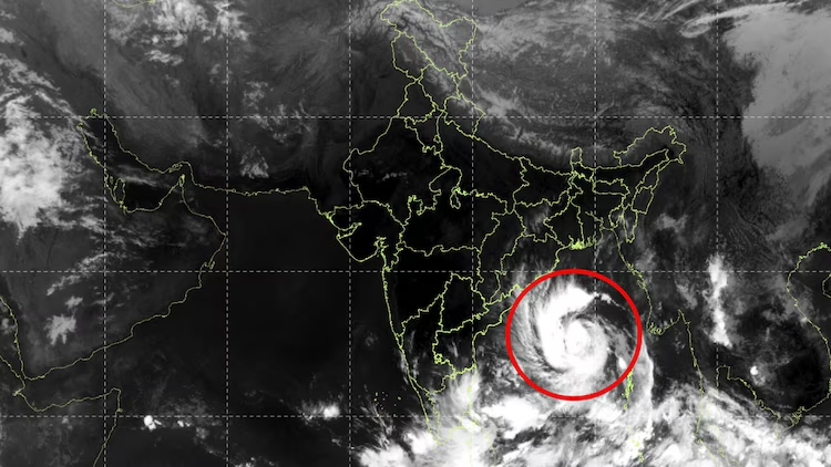
According to the IMD, Cyclonic Storm Arnab, pronounced “Ornab”, is forecast to intensify into a severe cyclonic storm by midnight on October 26 and further strengthen into a very severe cyclonic storm on October 27.
The weather system is expected to cross the Andhra Pradesh and Yanam coasts between Bapatla and Visakhapatnam, close to Yanam, by the forenoon of October 28. At landfall, the cyclone could produce maximum sustained winds of 115-125 kmph, with gusts reaching 140 kmph.
Cyclone Arnab’s current position and movement
In its bulletin issued at 5.30 am on October 26, the IMD located Cyclone Arnab over the east-central and adjoining west-central Bay of Bengal, near latitude 15.4°N and longitude 88.9°E.
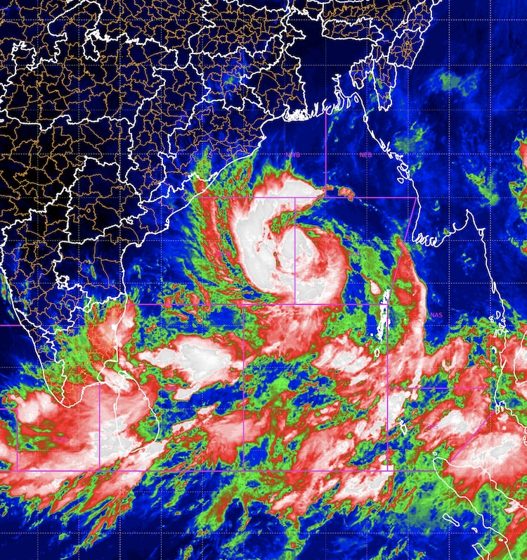
At that time, the storm was approximately 610 km southeast of Gopalpur in Odisha and 650 km east-southeast of Visakhapatnam in Andhra Pradesh. It had moved westwards at around 15 kmph during the preceding six hours after intensifying from a deep depression into a cyclonic storm.
The IMD expects the system to continue moving west-northwestwards before turning northwestwards towards the Andhra Pradesh coast. Its projected path places the coastline between Bapatla and Visakhapatnam, including the Yanam region, within the potential impact zone.
The cyclone’s track and intensity may change as it develops. Meteorologists are continuing to assess satellite observations and weather-model guidance to refine the forecast.
INSAT-3DS imagery captures the storm’s structure
India’s INSAT-3DS weather satellite is providing observations of the cyclone’s cloud structure and surrounding weather activity.
The IMD’s satellite bulletin identified a vortex associated with Arnab over the east-central and adjoining west-central Bay of Bengal, with intense to very intense convection around the storm system. Such observations help meteorologists assess the organisation of a developing cyclone and monitor changes in its cloud patterns.
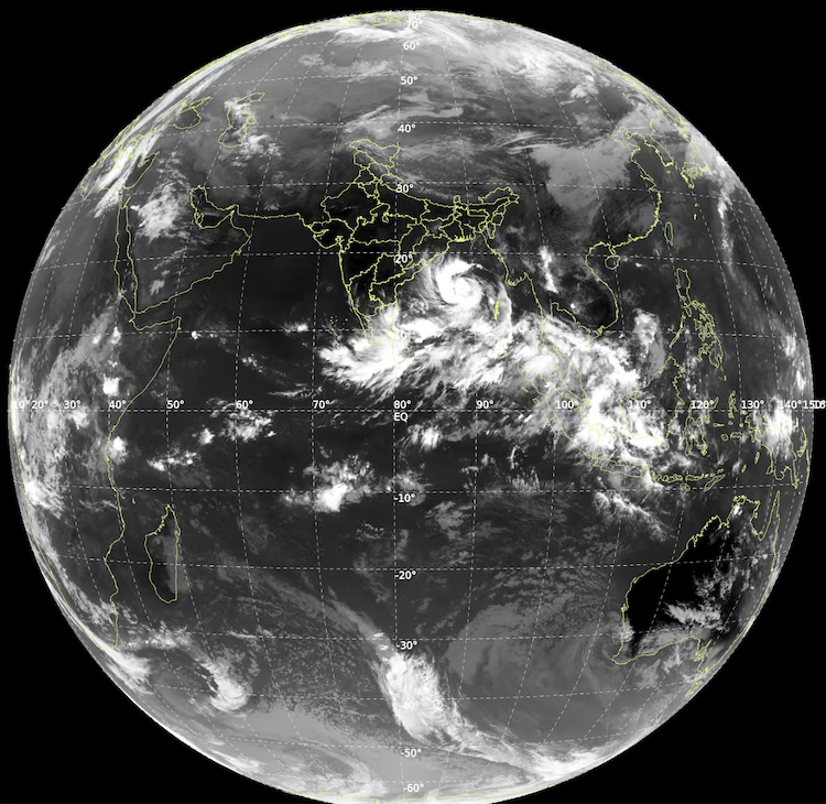
Satellite imagery is particularly important when a cyclone is still over the sea and direct observations from land-based weather stations are limited. It allows forecasters to track the storm’s position and monitor its development as it approaches the coast.
The imagery provides a view of the cyclone’s structure, but the final impacts on land will depend on its movement, strength, rainfall distribution and local conditions at the time of landfall.
Red-level warning issued for Andhra Pradesh and south Odisha
The IMD has issued a red-level cyclone warning for Andhra Pradesh and adjoining south Odisha as Arnab is forecast to intensify over the next two days.
A red warning indicates the need for the highest level of preparedness in the areas covered by the alert. Strong winds, heavy rainfall and rough seas can create risks for coastal communities, transport networks, power infrastructure and temporary structures.
The IMD has also issued district-level rainfall warnings for Andhra Pradesh as the system approaches. A report published on October 26 said red alerts were in place for several districts for October 28, while other areas faced orange or yellow warnings depending on the forecast rainfall. Residents should check the latest district-specific advisories, as warning categories and affected locations can change with subsequent bulletins. Authorities in vulnerable areas are expected to monitor the cyclone’s progress and take precautionary measures based on official forecasts. Residents should follow instructions from district administrations and disaster-management agencies, particularly if evacuation or movement restrictions are announced.
Strong winds could damage coastal infrastructure
At the projected landfall intensity, sustained winds of 115-125 kmph and gusts of up to 140 kmph could damage trees, power lines, temporary structures and vulnerable buildings.
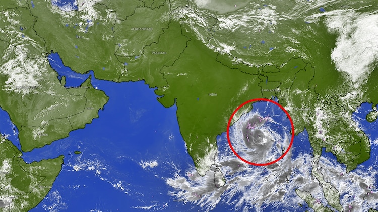
Strong winds can also disrupt electricity supply and telecommunications, while fallen branches and debris may obstruct roads. Coastal areas may experience dangerous sea conditions, affecting fishing, boating and other maritime activities.
Heavy rainfall associated with the cyclone could lead to waterlogging and flooding in low-lying areas. The extent of rainfall and the locations most at risk will depend on the storm’s final track and the distribution of its rain bands.
Residents should secure loose outdoor objects, stay away from damaged electrical infrastructure and avoid travelling through flooded roads. People living in vulnerable structures or low-lying coastal areas should pay attention to official safety instructions.
Fishermen and operators of small vessels should follow the IMD’s marine warnings and directions issued by local authorities. Venturing into rough seas during a cyclone can be extremely dangerous.
Expected landfall between Bapatla and Visakhapatnam
The current IMD forecast places the expected landfall between Bapatla and Visakhapatnam, close to Yanam, by the forenoon of October 28.
The forecast indicates that Arnab is likely to strengthen into a very severe cyclonic storm before reaching the coast. However, the precise point of landfall, timing and intensity remain subject to updates as the system moves closer to land.
Coastal districts should therefore prepare for possible disruption even if they are not directly in the projected landfall area. The effects of a cyclone can extend well beyond the point where its centre crosses the coastline, particularly through rainfall, strong winds and rough seas.
The IMD’s subsequent bulletins will be important for clarifying the storm’s track and identifying areas facing the greatest risk.
What residents should do as the cyclone approaches
With Arnab forecast to intensify, residents in potentially affected districts should rely on official weather bulletins rather than unverified messages circulating on social media.
People should keep essential medicines, drinking water, torchlights, charged mobile phones and important documents ready in case of power outages or evacuation. Loose objects around homes should be secured, and people should avoid standing near trees, unstable structures or overhead electrical lines during strong winds.
Residents should also avoid beaches, harbours and other exposed coastal locations when authorities advise against access. Anyone instructed to move to a designated shelter should follow the directions of local officials.
The forecast may change as fresh satellite observations and weather data become available. Checking updated IMD advisories and district administration announcements will help residents respond to the latest information.
Satellite tracking continues as Arnab approaches the coast
INSAT-3DS observations have provided a view of Cyclone Arnab’s organised cloud structure over the Bay of Bengal as the system moves towards India’s eastern coastline.
The IMD expects the storm to intensify into a very severe cyclonic storm before crossing the Andhra Pradesh and Yanam coasts between Bapatla and Visakhapatnam on October 28. Forecast wind speeds at landfall could reach 115-125 kmph, with gusts of up to 140 kmph.
With red-level warnings issued for Andhra Pradesh and adjoining south Odisha, preparedness and timely access to official advisories remain crucial. The cyclone’s eventual impact will depend on its final track, intensity and rainfall pattern, making continued monitoring essential over the coming days.