







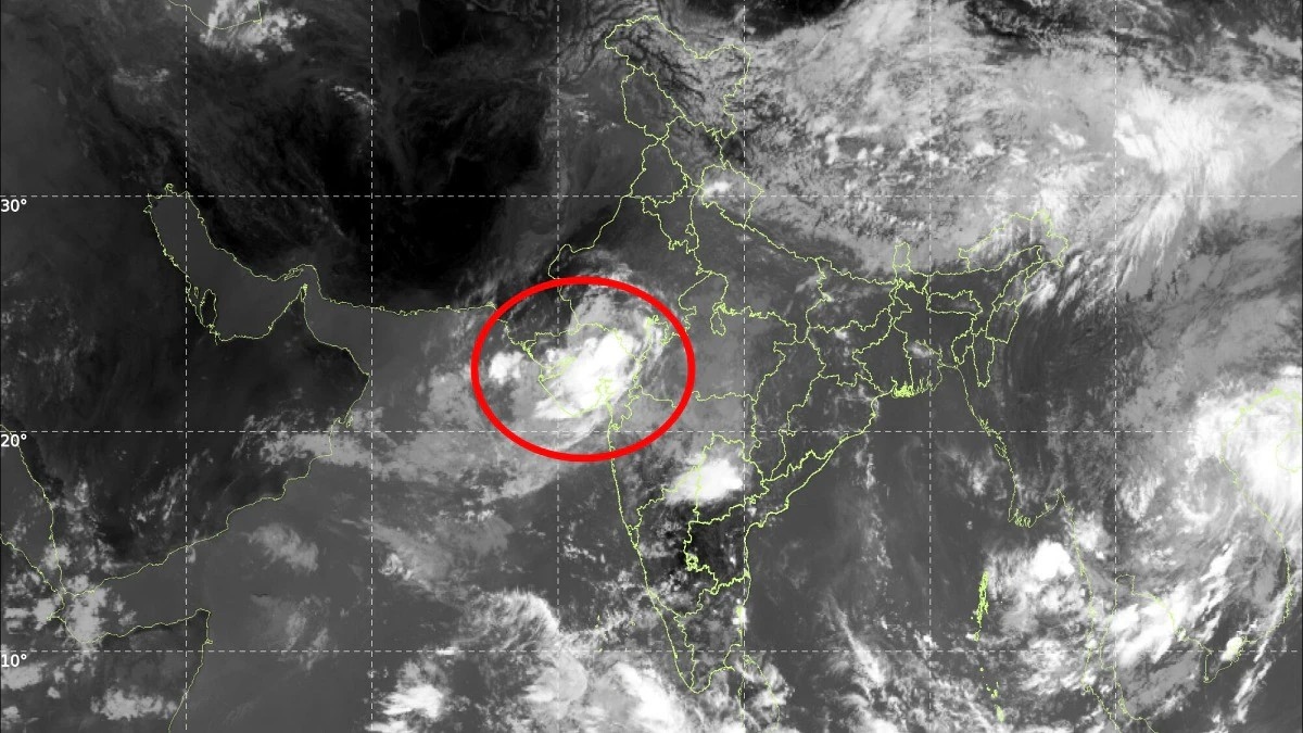


Ahmedabad : A massive rain-bearing cloud system has developed over Gujarat, prompting heightened attention as heavy rainfall continues across parts of the State. Satellite imagery from INSAT-3DS has captured a vast cloud mass associated with a low-pressure area, indicating the potential for further intense monsoon activity.
The weather system has brought substantial moisture into the region and is expected to continue influencing rainfall conditions. The satellite observations provide a clear picture of the scale of the cloud formation and its potential to produce heavy rain.
INSAT-3DS captures vast cloud formation
The INSAT-3DS satellite imagery showed an extensive cloud mass covering large parts of Gujarat. Such satellite observations help meteorologists track the development and movement of weather systems and assess their potential impact.
The cloud formation has been linked to a low-pressure area, a weather system that can draw moisture towards a region and produce widespread rainfall.
With the monsoon remaining active, the presence of a large moisture-bearing system has increased the possibility of continued heavy rain in affected areas.
Heavy rainfall likely to continue
The weather system is expected to keep Gujarat under the influence of significant rainfall. Areas already experiencing heavy showers could see further spells as the system moves and develops.
Persistent heavy rain can increase the risk of waterlogging, flooding and disruption to transport, particularly in low-lying areas and places where drainage systems are unable to cope with intense rainfall.
Residents in vulnerable locations are therefore advised to remain alert to official weather warnings and local administration advisories.
Satellite monitoring helps track monsoon systems
Satellite imagery plays an important role in monitoring India’s monsoon. INSAT-3DS provides meteorological observations that help track clouds, rainfall systems and other atmospheric conditions.
Images from the satellite can give meteorologists an overview of large weather systems that may not be immediately visible from ground observations. This information contributes to forecasting and early warnings during periods of severe weather.
The latest imagery over Gujarat demonstrates the scale of the rain-bearing cloud formation associated with the current low-pressure system.
Monsoon remains active
The development comes during an active phase of the southwest monsoon, which continues to influence weather conditions across several parts of India.
Low-pressure systems are a regular feature of the monsoon season and can bring widespread rainfall when they interact with moisture-laden winds. Depending on their movement and intensity, they can also result in prolonged or very heavy rainfall over particular regions.
For Gujarat, continued monitoring will be important as the current system develops.
Residents advised to remain cautious
With heavy rain expected to persist, residents should remain cautious in areas prone to flooding or waterlogging. People travelling during periods of intense rainfall should also stay updated on local road and transport conditions.
Authorities and weather agencies are expected to continue monitoring the system through satellite observations and other meteorological data.
The latest INSAT-3DS imagery offers a striking view of the scale of the monsoon cloud system over Gujarat, while also highlighting the continuing need for preparedness as heavy rainfall affects parts of the State.