





London: Temperatures in parts of the United Kingdom are forecast to climb to an unusually warm 23C before colder air brings a more typical autumn chill across the country. Eastern England could experience afternoon temperatures 5-8C above the seasonal average, while Scotland and Northern Ireland are expected to remain considerably cooler.
The contrasting conditions are being driven by two different air masses separated by a weather front moving gradually southwards. While southerly winds are bringing warmer air into central, eastern and southern England, northern parts of the UK are already experiencing cooler conditions and rain.
As the weather front moves further south, temperatures are expected to fall across the country by Friday and remain relatively low over the weekend. Sunshine is still likely in many areas, but chilly nights, patchy fog and a risk of frost could make conditions feel increasingly autumnal.
Eastern England could see temperatures reach 23C
Parts of eastern England are expected to experience the warmest conditions, with afternoon temperatures potentially reaching 19-23C.
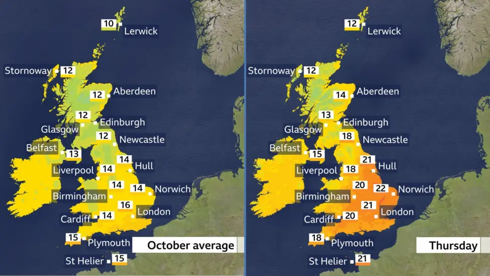
The warmer weather is being driven by brisk southerly winds associated with a deep area of low pressure passing close to Iceland. These winds are drawing warmer air towards central, eastern and southern parts of England.
Sunny spells are expected to help temperatures rise, creating a brief period of unseasonably warm weather despite the move towards the middle of autumn.
The forecast high of 23C would be around 5-8C above typical mid-October temperatures in some eastern areas. Such conditions would contrast sharply with the cooler weather expected across northern parts of the country.
The warm spell is expected to be short-lived, however, as colder air advances southwards behind the weather front.
Rain moves south across England and Wales
A weather front that has already brought rain to Scotland and Northern Ireland is forecast to edge southwards on Thursday.
As it moves, northern England, Wales and parts of south-west England could experience periods of rain, making for a wet afternoon in several areas.
The front marks the boundary between the warmer air affecting much of southern and eastern England and cooler air already established further north.
The rain is expected to gradually clear from northern parts of the UK, allowing Scotland and Northern Ireland to turn mostly sunny. However, blustery winds and scattered heavy showers could continue in these regions.
Afternoon temperatures in Scotland and Northern Ireland are forecast to range from 12C to 15C, significantly below the highs expected in eastern England.
These cooler conditions will provide an indication of the broader change expected as the weather front continues its journey southwards.
Colder air to bring an autumnal weekend
Conditions are expected to become more uniformly autumnal from Friday as high pressure builds from the west and northerly winds bring colder air across the UK.
Daytime temperatures are forecast to settle between 10C and 16C across the country, closer to the usual October range.
However, the wind could make conditions feel colder than the thermometer suggests, particularly along the eastern coasts of Scotland and England, where blustery conditions are expected.
Although high pressure should bring sunny spells to many areas, it will not necessarily mean completely dry weather.
A few showers are possible, particularly across northern and western parts of the UK on Friday. Over the weekend, showers could affect south-east England as well.
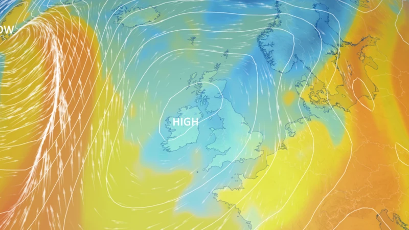
The combination of sunshine, occasional showers and colder winds is expected to create a more typical autumn weather pattern after the brief spell of warmth.
Frost and patchy fog possible overnight
The fall in temperatures is expected to be more noticeable overnight, with minimum temperatures dropping into single figures in almost all areas.
Some locations could experience a touch of frost, while patchy mist and fog may develop in places.
Temperatures are forecast to fall below freezing in parts of Scotland, Northern Ireland and northern England. These areas could experience some of the coldest conditions of the autumn so far.
The risk of frost will depend on local conditions, including cloud cover, wind strength and how quickly the ground loses heat overnight.
Clear skies can allow temperatures to fall more rapidly, increasing the likelihood of frost in sheltered areas. Fog may also form in locations where conditions are favourable for moisture to condense near the ground.
Despite the prospect of a sharp change from the warmer daytime conditions, the forecast temperatures are not considered unusual for this time of year.
What is driving the change in weather?
The changing conditions reflect the movement of different air masses across the UK.
The southerly winds ahead of the weather front are bringing relatively warm air into England, particularly its central, eastern and southern regions. This is expected to support the higher daytime temperatures on Thursday.
Further north, the weather front has already brought rain and cooler conditions. As it moves south, the warmer air will gradually be replaced by colder air arriving from the north.
The development of high pressure from the west is expected to influence the weather towards the end of the week. It should bring periods of sunshine, even as northerly winds lower temperatures.
This means the UK could move from a sharp regional contrast in temperatures on Thursday to a more consistently cool pattern over the weekend.
Long-range forecast remains uncertain
The outlook for the following week is less certain, with computer weather models offering conflicting indications of how conditions may develop.
High pressure is expected to remain close to the UK initially, potentially maintaining settled conditions in several areas.
However, there are indications that weather systems moving in from the Atlantic could eventually break through. If that happens, the country could see a return to wetter, windier and somewhat milder conditions.
The timing and extent of any change remain uncertain, so the longer-range outlook could change as new forecasts become available.
For now, the immediate forecast points to a brief spell of unusually warm weather in parts of England, followed by a more widespread autumn chill.
UK prepares for a sharp temperature contrast
Thursday’s forecast highlights the contrast between the warm air reaching eastern England and the cooler conditions already affecting Scotland and Northern Ireland.
Temperatures could reach 23C in some eastern areas before the weather front moves south and allows colder air to spread across the country.
By the weekend, daytime highs are expected to range from 10C to 16C, with chilly nights, possible frost and patchy fog adding to the autumn feel.
Although sunshine should continue in many locations, showers and blustery winds will remain possible.
The forecast for next week is still uncertain, but the immediate outlook suggests that the short-lived warmth will give way to temperatures more typical of October.